About Us
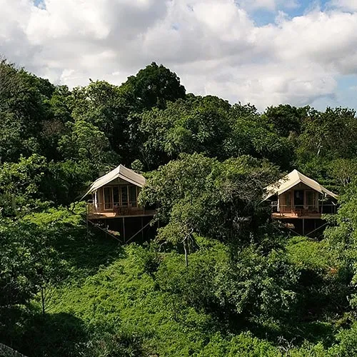
Our Safari Camp, roamed by wild giant tortoises and bordering the Galapagos National Park, is small by design and exclusive by definition. We design tailor-made safaris to meet incredible Galapagos wildlife.
Isabela Island: At a glance
- Inhabited by humans
- Largest island in Galapagos (4600 squared km; 1800 squared miles)
- Shaped like a sea-horse
- Formed when 6 volcanoes joined together
- Easy to reach from Galapagos Safari Camp (by plane or boat)
- Altitude: Highest peak is Wolf Volcano at 1700m / 5600ft.
- Originally called Albemarie Island, after the Duke of Albemarle, before being renamed after Isabela, The Queen of Spain (who sponsored Columbus’ expedition).
- * Home to the very rare and endemic pink iguana of Wolf Volcano. This has been one of science’s most exciting discoveries in recent years, a spectacular find, that unfortunately, is not part of the Galapagos tourism circuit since the area in which it exists is not an official visitor site. David Attenborough had his connections, however, and was able to catch it on film (albeit very briefly).
Isabela Island Safari Highlights
- Scenic flight
- Sierra Negra volcanic crater & lava fields.
- Los Tuneles – snorkeling site
- Tintoreras – snorkeling site
- Beach
- Animals to look out for: Marine Iguanas, Giant Tortoises, Penguins, Blue-Footed Boobies, Finches, Pelicans, Sally Lightfoot Crabs, Galapagos Hawks.
Why include Isabela on your Galapagos Tour?
All our Land-Based Galapagos Safaris can be extended by 3 or 4 days to include Isabela, the largest of the Galapagos islands. Shaped like a sea-horse, it sits in the westernmost part of the archipelago and is one of the youngest islands in the Galapagos.
1) Easy to access
On the southern coast of Isabela is Puerto Villamil, one of the Galapagos Islands’ four inhabited ports. From Galapagos Safari Camp, you can easily reach Puerto Villamil by boat (2 – 2.5 hours) or on a small propeller plane (30 minutes). We personally prefer the flight. The waters in this stretch of ocean can get quite choppy and if you’re a prone to seasickness, you’ll be much better off flying.
2) The most scenic flight in the Galapagos
The short flight to Isabela gives guests a spectacular bird’s eye view of the Enchanted Islands. In contrast to the Baltra – San Cristobal flight path which only crosses open water, the flight to Isabela is a lot more scenic. Taking off from Baltra (the tiny airport island that serves Santa Cruz), the flight heads west, skirting the northern coastline of Santa Cruz, with the little rocky islands of Daphne and Daphne Menor to your right and the highlands of Santa Cruz to your left. If you ask the pilot, he or she may even be able to point out Galapagos Safari Camp for you. On a clear day you may be able to see the uninhabited islands of Santiago and Rabida to your right and Isla Pinzon almost directly beneath you. As you approach Isabela look out for ‘Los Cuatro Hermanos’ (The Four Brothers), a chain of volcanic islets usually covered in seabirds, marine iguanas and sea lions. The final descent cuts across the south-eastern corner of Isabela, before landing on a tiny air-strip in Puerto Villamil.
3) Geology
It’s only as you approach the barren, volcanic coastline of Isabela by air that you get a sense of its extraordinary geology. Sat close to the Galapagos volcanic hotspot, Isabela is nearly one million years old and one of the youngest islands in the archipelago. It was formed when six separate volcanoes – Ecuador, Wolf, Darwin, Alcedo, Sierra Negra, and Cerro Azul – fused together to create one big volcanic island. With the exception of Ecuador, all the volcanoes are still active but very closely monitored to keep the islands’ residents and visitors safe.
In order to gain a better understanding of why the Galapagos Islands are so unique, it is important to learn something of their geology. Even Darwin dedicated more pages of his books to geology than to zoology. As such, we highly recommend extending your Safari to include Isabela, and, in particular, some of its unusual geological sites.
4) Hike Sierra Negra Volcano
The geologist, Walter. L. Manger once said, “To learn geology one must travel widely and observe carefully, for geology is learned through the soles of your shoes, not the seat of your pants!” And we would agree!
Our guided hike up Sierra Negra follows a 16km (relatively flat) trail to the volcano’s giant caldera. Out of the 6 volcanoes on Isabela, Sierra Negra is the only one that tourists are permitted to access and the views across the caldera are spectacular. Stretching 6 miles / 11km in diameter, it is the largest caldera in the Galapagos and certainly one of the most active. The floor is covered in dark solidified lava from the eruption in 2005.
The trail skirts the edge of the caldera before veering off into the lunar-like lava fields north east of the crater. Follow the advice of Walter. L. Manger and, “Delve deeply into the rocks, for truth is hidden there. Take heed to observe carefully the seemingly insignificant things, as each and every phenomenon and event is an integral part of nature’s process.”
This excursion focuses more on the geology of the Galapagos than its wildlife. However, you may see Galapagos Finches and Mockingbirds. From the end of the lava fields there is also an impressive view of Elizabeth Bay.
The walk takes 5-6 hours in total. Although the incline is gradual, the hike can be strenuous for some due to the heat of the Ecuadorian sun. With Galapagos Safari Camp this guided hike is a private tour, and so you can always opt to walk just to the crater (a round trip of 3 hours), depending on how you feel at the time.
5) Los Tuneles (The Tunnels)
One of the best snorkeling sites on Isabela is Los Tuneles on the west of the island.
Also known as Cabo Rosa, this Venice-like volcanic world is made up of a series of semi-submerged lava tunnels and bridges. The only way visitors can access the tunnels is by boat, a trip that takes around 1-hour from Puerto Villimil.
Depending on the conditions of the sea on the day, the captain may decide to stop at a site just before Los Tuneles for a snorkel, before continuing to Los Tuneles. Both sites offer excellent opportunities to observe green turtles, rays, reef sharks, endemic seahorses and, arguably most exciting of all, Galapagos penguins!
Visitors may also disembark at Los Tuneles to explore the network of bridges on foot. Here you may encounter the odd Blue-Footed Booby, and depending on the time of year, possibly a chick as well.
The boat trip to Los Tuneles also swings by Roca Union, an imposing rocky outcrop sat in the ocean that is usually covered in Nazca Boobies.
6) Galapagos Penguins
Although you may get the opportunity to see penguins at Isla Bartolome on our Classic Safari, adding Isabela as a Safari Extension will help increase your chances of seeing these cute little creatures.
Endemic to the Galapagos Islands, and thousands of miles from Antarctica (where their ancestors are thought to have come) these remarkable birds are another excellent example of how animals have adapted to these remote islands. You can read more about the Galapagos Penguin here.
The best spots to see the penguins on Isabela are at Los Tuneles and Las Tintoreras.
7) Las Tintoreras
Another excellent snorkeling site we can take our guests to is Las Tintoreras, a cluster of small islets just south of Puerto Villamil. The turquoise waters are full of marine life and home to turtles, sea lions, rays, marine iguanas, sharks and penguins.
8) Wall of Tears
Depending on how many days you stay on Isabela, you may have time to fit in a leisurely stroll (or bicycle ride) to Humedales Reserve. Also known as ‘The Wetlands’, it is home to numerous giant tortoises, marine iguanas and seabirds. The reserve also contains El Muro de las Lágrimas (‘The Wall of Tears’), a wall built by the inmates of what was, until the 1950s, a penal colony on the island.
9) Puerto Villamil Beach
The beach at Puerto Villamil is also a place to kick back and bask in the sun alongside the resident marine iguanas. The perfect way to end your safari.
Galapagos Islands to Visit
To learn more about the other islands we visit, see our guides below:
Plan your Galapagos Vacation
For more information on extending your Galapagos Safari to include Isabela, see our Isabela Island Safari Extension.
Disclaimer: As with any wildlife holiday experience, we cannot guarantee that you will see each of the species mentioned in this article. Instead, please view this information as a guide, based on the first-hand experience of our expert naturalists and guests at Galapagos Safari Camp.